Geography
Main article: Geography of Italy
-

-

-
-

-
-
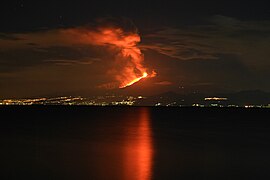 The legendary Mount Etna
-
-


Topographic map of Italy
The country's total area is 301,230 square kilometres (116,306 sq mi), of which 294,020 km2 (113,522 sq mi) is land and 7,210 km2 (2,784 sq mi) is water. Including the islands, Italy has a coastline and border of 7,600 kilometres (4,722 miles) on the Adriatic, Ionian, Tyrrhenian seas (740 km (460 mi)), and borders shared with France (488 km (303 mi)), Austria (430 km (267 mi)), Slovenia (232 km (144 mi)) and Switzerland (740 km (460 mi)). San Marino (39 km (24 mi)) and Vatican City (3.2 km (2.0 mi)), both enclaves, account for the remainder.
The Apennine Mountains form the peninsula's backbone and the Alps form most of its northern boundary, where Italy's highest point is located on Monte Bianco (4,810 m or 15,780 ft).[note 2] The Po, Italy's longest river (652 kilometres or 405 miles), flows from the Alps on the western border with France and crosses the Padan plain on its way to the Adriatic Sea. The five largest lakes are, in order of diminishing size:[79] Garda (367.94 km2 or 142 sq mi), Maggiore (212.51 km2 or 82 sq mi, shared with Switzerland), Como (145.9 km2 or 56 sq mi), Trasimeno (124.29 km2 or 48 sq mi) and Bolsena (113.55 km2 or 44 sq mi).

Mount Vesuvius, as seen from the ruins of Pompeii
Although the country comprises the Italian peninsula and most of the southern Alpine basin, some of Italy's territory extends beyond the Alpine basin and some islands are located outside the Eurasian continental shelf. These territories are the comuni of: Livigno, Sexten, Innichen, Toblach (in part), Chiusaforte, Tarvisio, Graun im Vinschgau (in part), which are all part of the Danube's drainage basin, while the Val di Lei constitutes part of the Rhine's basin and the islands of Lampedusa and Lampione are on the African continental shelf.
Environment

National (green) and regional (orange) parks in Italy
However, air pollution remains a severe problem, especially in the industrialised north, reaching the tenth highest level worldwide of industrial carbon dioxide emissions in the 1990s.[86] Italy is the twelfth largest carbon dioxide producer.[87][88] Extensive traffic and congestion in the largest metropolitan areas continue to cause severe environmental and health issues, even if smog levels have decreased dramatically since the 1970s and 1980s, and the presence of smog is becoming an increasingly rarer phenomenon and levels of sulphur dioxide are decreasing.[89]
Many watercourses and coastal stretches have also been contaminated by industrial and agricultural activity, while because of rising water levels, Venice has been regularly flooded throughout recent years. Waste from industrial activity is not always disposed of by legal means and has led to permanent health effects on inhabitants of affected areas, as in the case of the Seveso disaster. The country has also operated several nuclear reactors between 1963 and 1990 but, after the Chernobyl disaster and a referendum on the issue the nuclear programme was terminated, a decision that was overturned by the government in 2008, planning to build up to four nuclear power plants with French technology. This was in turn struck down by a referendum following the Fukushima nuclear accident.[90]
Deforestation, illegal building developments and poor land-management policies have led to significant erosion all over Italy's mountainous regions, leading to major ecological disasters like the 1963 Vajont Dam flood, the 1998 Sarno[91] and 2009 Messina mudslides

No comments:
Post a Comment